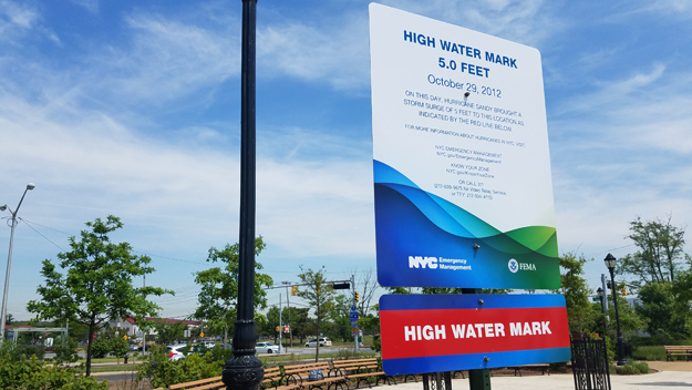
In mid-May, the first of 20 New York City-wide "High Water Mark" signs has gone up, this one on Staten Island. The ongoing educational campaign to raise coastal storm awareness, which is in tandem with an effort to revise the City's coastal storm evacuation signs, is a partnership of the Federal Emergency Management Agency, New York City's Office of Emergency Management and the National Oceanic and Atmospheric Administration's National Hurricane Center and New York Sea Grant. Photo: Alex Silverman/WCBS 880
New High Water Mark, Revised Coastal Storm Evacuation Signage
Midland Beach, NY, June 1, 2016 - New York's 2016 hurricane season begins today (June 1st) — and the city marked it by installing new signs to help residents prepare for the next storm.
The city's Office of Emergency Management installed the city's first "High Water Mark" sign — which shows how high the storm surge reached during Hurricane Sandy — in Midland Beach and updated evacuation route signs around Staten Island to help people find higher ground.
"Since we are now officially in hurricane season, every one should make sure that they are ready for the storm," said Joseph Esposito, OEM commissioner.
The city installed 57 new evacuation route signs around the borough that, unlike previous ones that simply told people where to go in case of a storm, points drivers in the direction of higher ground and shows if they're still in a flood zone, Esposito said.
"Most people in the city, especially on Staten Island, if you're going to evacuate you know where you're going," Esposito said.
"You know the best route to get to that location. What these signs are for is to show that you're still in harm's way. If you see these signs, you better keep going until you don't see the signs anymore."
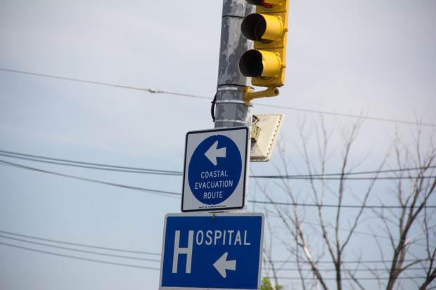
The city installed 57 updated evacuation route signs around Staten Island that serve as a notice that residents are still inside a flood zone. Photo credit: DNAinfo/Nicholas Rizzi
The city partnered with FEMA to place the first of 20 "High Water Mark" signs inside the Midland Beach Splaza that show how high the storm surge reached in the park during Sandy.
"We want everybody to remember what it was like, so we don't forget, we never forget, the devastation that occurred," said Michael Moriarty, director of FEMA Region II's mitigation division.
"[The signs] make sure that when residents come to the beach years from now, they're still going to remember that the water was this high during Sandy and that we have to take proper precautions."
The signs are part of a FEMA pilot program around the country that aims to raise awareness about flood zones. The OEM plans to place the others in neighborhoods hit hard by Sandy around the city by the end of the year.
Esposito urged residents to stay safe if a storm hits the city by knowing which flood zone they live in, developing a plan and packing a go bag before the storm.
The city plans to hand out 100,000 pamphlets in high-risk neighborhoods around the city.
Since many of the deaths during Sandy were caused by people who didn't evacuate their homes, Esposito said the OEM has partnered with the NYPD to create a system that will send officers to canvass the neighborhood and warn residents to flee before the next storm.
"It will be a pre-evacuation canvass where they'll knock on the door and tell people, 'Hey, you are in a zone that's been ordered evacuated,'" Esposito said.
"We're going to highlight that the majority of people that died in Sandy would not have died if they evacuated."
—Nicholas Rizzi, DNAInfo.com
More Info: Revised Coastal Storm Evacuation Signage
VIDEO: June 1, 2016 was a sunny start to the Atlantic Hurricane season in New
York City. This year the city's changing the way it marks evacuation
routes. More from WCBS Newsradio 880's Alex Silverman, who's in Ocean
Breeze, Staten Island.
AUDIO: NYC Marks Start Of Atlantic Hurricane Season With New Flood Safety Initiatives
Note: If you don't see the player above, it's because you're using a non-Flash device (eg, iPhone or iPad).
New York, NY, June 1, 2016 - June 1 marks the official start of Atlantic hurricane season — and this year, the city is implementing new changes to the way it marks evacuation routes on Staten Island and across the city.
The new signs will mark the borders of designated hurricane or coastal flooding zones — rather than marking an evacuation center, WCBS 880’s Alex Silverman reported.
“Instead of telling you where to go, it’s more or less giving the effect that you’re in a zone,” Office of Emergency Management Commissioner Joe Esposito said. “Keep going until you don’t see the signs anymore.”
Travelers will know they are out of a designated hurricane zone once they stop seeing the signs.
The Office of Emergency Management unveiled one of many high water warning signs at Midland Beach in Staten Island on Wednesday. A sign at Ocean Breeze has a big red line five feet off the ground — designating Superstorm Sandy’s high water mark.
The changes are a part of a FEMA program aimed to keep the risk of flooding apparent even on a brilliant sunny day and to hopefully prevent future flooding.
—Alex Silverman, WCBS News Radio 880
More Info: FEMA's Know Your Zone Campaign
Evacuation orders or flood warnings are rather meaningless if people don’t know where they live, relative to the scope of those orders or warnings. Some may leave their homes unnecessarily, while others who need to leave remain at home. And do people actually know where those evacuation signs lead? In 2013, New York City's Office of Emergency Management revised the City's hurricane evacuation zones and initiated a “Know Your Zone” campaign with maps to help familiarize residents with these changes.
More Info: NOAA Sea Grant's Coastal Storm Awareness Program
Released in late May 2016, the NOAA Sea Grant Documentary Short on coastal storm awareness educates emergency managers and empowers coastal communities. The video also points to resources from NOAA's National Weather Service, the Federal Emergency Management Agency and NYC's Office of Emergency Management.
The 4-1/2 minute trailer for NOAA Sea Grant's Coastal Storm Awareness Program's 23-minute documentary, view-able on YouTube.
More Info: New York Sea Grant
New York Sea Grant (NYSG), a cooperative program of Cornell University
and the State University of New York, is one of 33 university-based
programs under the National Sea Grant College Program (NSGCP) of the
National Oceanic and Atmospheric Administration (NOAA). The NSGCP
engages this network of the nation’s top universities in conducting
scientific research, education, training and extension projects designed
to foster science-based decisions about the use and conservation of our
aquatic resources. Through its statewide network of integrated
services, NYSG has been promoting coastal vitality, environmental
sustainability, and citizen awareness about the State’s marine and Great
Lakes resources since 1971.
New York Sea Grant maintains Great Lakes offices at SUNY Buffalo, the
Wayne County Cooperative Extension office in Newark and at SUNY Oswego.
In the State's marine waters, NYSG has offices at Stony Brook University
and Stony Brook Manhattan, in the Hudson Valley through Cooperative
Extension in Kingston and at Brooklyn College.
For updates on Sea Grant activities: www.nyseagrant.org has RSS, Facebook, Twitter, and YouTube links. NYSG also offers a free e-list sign up via www.nyseagrant.org/coastlines for its flagship publication, NY Coastlines/Currents, which is published several times a year.